
Question: Why do we need Geographic Information Systems like Quantum GIS, ArcInfo, ArcView, MapInfo, Caliper software, GRASS and Manifold?
The answer: In this Introduction To GIS Data Concepts, I’m going to suggest to you that Google Maps simply doesn’t provide the capabilities to handle a sophisticated GIS project. Your ability to incorporate your own maps and data is very limited, such as: digitizing capabilities, analysis tools, and presentation tools.
From Google Maps To GIS
To get started with GIS, you’ll need a basic understanding of database concepts. The most noticeable difference between a desktop geographic information system and a web system like Google Maps is: with a desktop GIS you can explore relationships descriptively and quantitatively as well as visually.
For example, it’s very easy to bring up a Google map and count the number of houses in an area that abuts a freeway. Houses are easy to see in an air photo. But in Google Maps it would be near-impossible to count every house abutting every freeway in an entire city, or country! That’s what I mean by quantitative. With a GIS you can explore huge databases with simple queries.
Explicit database relationships
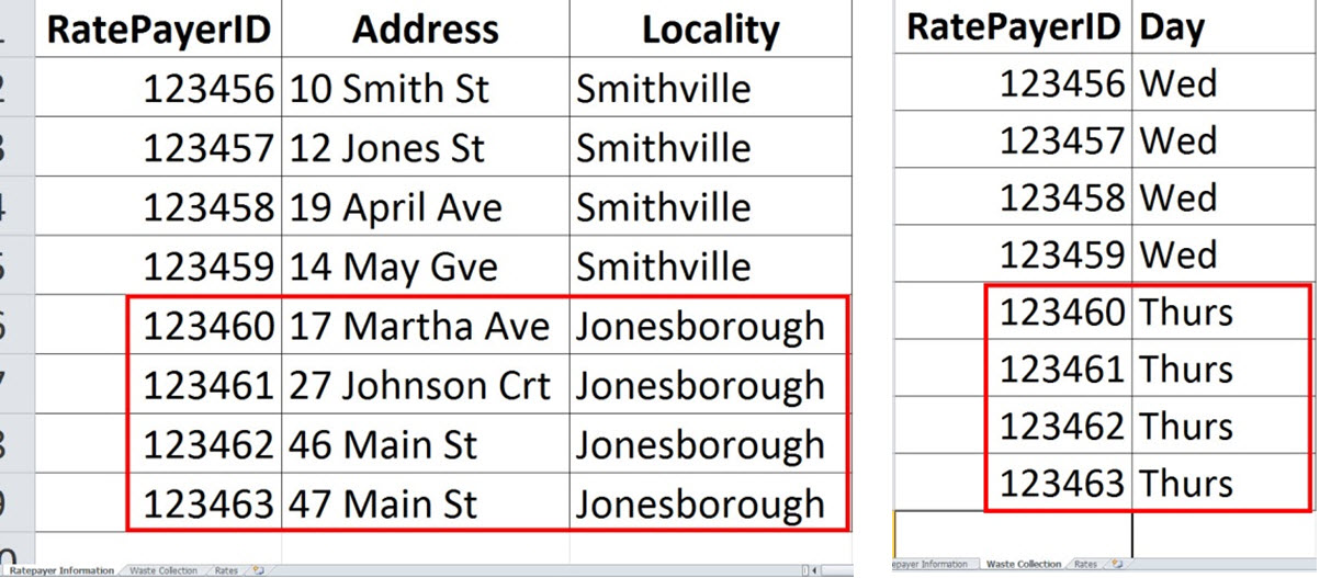
Relational database systems are common in Universities, Councils, Governments, Corporations, etc. If we were looking at a Council database, you might have 3 different tables (figure 1). Think of a table as a being like an Excel Spreadsheet. A Workbook might be called “Council database”, and it might contain worksheets called ‘Ratepayer information’, ‘waste collection’, ‘Rates’, etc. To answer the query “Give me the names and addresses of all ratepayers who have their rubbish collected on a Thursday”, a Council would relate the RatepayerID (key field – because its the ‘key’ to the file) in the “Ratepayer Information” and “Waste collection” tables to each other to select the four rows in figure 1.
Implicit geographical relationships
In a GIS we can also relate information to other information by its “implicit” geographical relationship rather than an “explicit” database relationship. That means that there’s a whole bunch of previously incompatible information out there that can be related to other information based on its geography. By “implicit” I mean that…
- Something might be NEXT TO something else – a house might be NEXT TO a freeway.
- Something might be WITHIN something else – a rare plant WITHIN a park.
Explicit database relationships and Implicit geographical relationships combined
Geographical information systems become really powerful when you combine “explicit” and “implicit” queries. For example, if Council knew of planned freeway works on one Thursday, they could notify all the affected ratepayers by asking their GIS the question “Tell me all ratepayers that get their bins picked up on Thursday and who live next to the freeway?”
Introduction To GIS Data Concepts – Conclusion
So, I suppose that for the purpose of this Introduction To GIS Data Concepts article, an understanding the concepts of “explicit” database relationships and “implicit” geographical relationships is extremely important if you are to use a GIS productively. If you get your head around this stuff, the projects and the analyses that you’ll be able to do will just blow your mind!
We’d love to hear your comments on the article. If you have any questions, write them below.
You may also enjoy reading other articles, from the wide selection in the right-hand sidebar.