
Introduction
GIS refers to the Geographical Information System. It is a computerized system for data administration and serves the intention of capturing, saving, organizing, retrieving, analyzing and displaying spatial information. Spatial data refers to any data that is unswervingly connected to a specific location or geographical area.
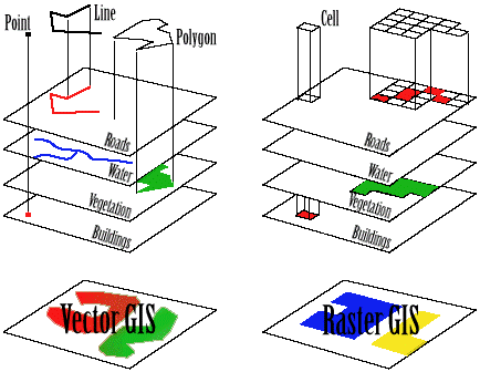
Fig. 1: Vector and Raster GIS
GIS uses two types of data:
- Raster data: refers to discrete cells in a rigid row by column format, e.g. satellite or aerial images.
- Vector data: refers to features on the surface of the earth represented by points, lines and polygons.
Most GIS systems use a combination of both types of data. A common GIS has several features, including the following:
- It enables the user to input digitized data that is geographically referenced to a certain location.
- It enables the user to use relational database management to link certain attributes to each feature.
- It enables the user to analyze relationships between several geographic features with the help of a vast range of spatial operations and features.
- It enables the user to produce high quality images on color monitors or plotters.
However, in this assignment, we will be discussing Vector data.
What is Vector Data?
Vectors portray the spatial features in the form of points, lines or polygons (often referred to as geometries). These are linked to the spatial database to a row that explains the attributes. For example, a spatial database about rivers may contain data regarding the depth and water quality etc. A vector map can plot a combination of spatial features in the form of lines, points and polygons. For example, a vector map can show the number of deep rivers (lines) within 1 km of forests (points).
Fig 2 below shows an example of a vector map.

Fig 2: Vector Map
The vector map above shows a combination of spatial features in one map. The locations, area and quantity of wells can be easily identified.
Advantages and Disadvantages
Some of the pros and cons of vector maps are mentioned below:
| Advantages | Disadvantages |
| Requires less storage space | More expensive |
| Clear and smooth vision | Location for each vertex needs to be stored separately |
| Easy overlay options | Requires extensive data cleaning |
| Easy to register, measure and reproduce | Not suitable for large databases |
| More compatible with relational databases | Variable data is not accurately portrayed |
| File sizes are smaller | |
| Simple to update and maintain |
Table 1: Pros and Cons of Vector Maps
Below is a visual difference between a vector and raster view of the world.

Fig 3. Difference between Vector and Raster view of the world
Vector Models
Vectors use the following models to store and manage the data:
- List of coordinates (Spaghetti mode)
- user digitizes data by specifying start and end points
- Vertex dictionary
- no topology; no duplication
- Dual independent map encoding
- codes represent nodes
- assigns directions ‘from’ and ‘to’
- street addresses and UTM are separately defined
- Arc/Node
- user specifies nodes to display a topology
In vector illustration, the storage of the vertices for every trait is significant, as well as the connectivity between features, e.g. the sharing of common vertices where features connect.
Vector data is generally better to use when producing high quality images in GIS. It is more detailed, clear, readable and user friendly as compared to raster data. There are several models of vector data, however only two are most commonly used in GIS:
- The CAD (Computer-Aided Drafting) is an example of a vector data structure. The latest technology of the GPS also uses CAD data structure, where 3D images can be displayed when searching a location.
- Topological data structure which is also known as the ‘intelligent data structure’. It enables quick and easy derivation of the spatial features of a certain area.
Vector data requires less storage space, efficiency, accuracy, clear vision, ease in reproducing, registering and measuring, compatible with relational databases, produce smaller sized files, and therefore consume minimum space and are very simple to update and maintain.
References:
http://www.geogra.uah.es/patxi/gisweb/GISModule/GIST_Vector.htm
http://www.colorado.edu/geography/gcraft/notes/datacon/datacon.html
http://bgis.sanbi.org/gis-primer/page_16.htm